Service
E57 Point Cloud File
Exported E57 point cloud data for downstream surveying, modeling, and verification workflows.
Exported E57 point cloud data for downstream surveying, modeling, and verification workflows.
 Industry-standard format Dense spatial data Compatible with major tools Accurate as-built context
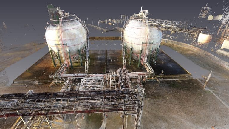
An E57 point cloud file is a vendor-neutral format used to deliver scan-based 3D data for surveying, modeling, verification, and design workflows. It preserves dense spatial information from the capture process and serves as a reference layer for teams that need more than a visual tour or static drawing.
At View As Built, our E57 point cloud deliverables are intended for architecture, engineering, construction, design, and facility projects in Boca Raton and throughout South Florida. These files are especially useful when downstream teams need to bring scan data into their own software environment for modeling, analysis, coordination, or existing conditions review.
Point cloud data helps reduce uncertainty by giving teams a detailed record of what was actually on site at the time of capture. That is valuable for renovation planning, as-built verification, clash review, scan-to-BIM workflows, and projects where field revisits are expensive or difficult to coordinate.
Because point cloud deliverables need to fit the client's software stack and intended workflow, we scope around density, coverage, format expectations, and downstream use. If your team needs E57 output for Revit, AutoCAD, surveying, verification, or broader coordination workflows, we can align the deliverable to that use case so the data is more immediately usable.
If you need 3D scanning, virtual tours, floor plans, point cloud data, CAD / BIM-ready files, or property documentation in Boca Raton or anywhere in South Florida, View As Built is ready to help.
Reach out to discuss your property, timeline, and the deliverables that will bring the most value to your project.